Fabulous
Mystery of Pyramid Placement Solved: Why They Chose the Desert
North Carolina - May 17, 2024 - The Nile's Lost Embrace: New Theory Explains Placement of Egyptian Pyramids.

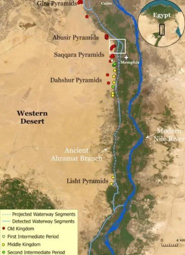
A team of researchers from the University of North Carolina Wilmington (UNCW) may have cracked the code on a long-standing mystery: the placement of Egypt's iconic pyramids in what is now a desolate desert landscape. Their findings, published in a recent study, suggest the pyramids were originally built alongside a long-lost branch of the Nile River, a lush green ribbon that has vanished beneath the sands of time.
The sight of the majestic Egyptian pyramids rising from the arid expanse of the Sahara Desert is a powerful image, yet it presents a puzzling question. Why would such monumental structures be built so far from the life-giving waters of the Nile River, the historical lifeline of Egyptian civilization? The nearest major water source is currently located a staggering five miles away.
UNCW researchers, led by Dr. Eman Ghoneim, believe they have the answer. Through meticulous analysis of satellite imagery and by meticulously collecting soil samples, they have uncovered compelling evidence for the existence of a previously unknown branch of the Nile River, the Ahramat Branch. This ancient waterway, estimated to be 40 miles long (64 kilometers), would have flowed near the pyramid fields, transforming the surrounding landscape into a fertile oasis.

The Ahramat Branch, the researchers propose, would have extended the verdant strip of land nurtured by the Nile River further into the desert. This lush environment would have offered significant advantages to the pyramid builders, facilitating transportation of materials and potentially serving as a source of sustenance for the workforce.
Latest News
North Carolina - May 17, 2024 - The Nile's Lost Embrace: New Theory Explains Placement of Egyptian Pyramids.

A team of researchers from the University of North Carolina Wilmington (UNCW) may have cracked the code on a long-standing mystery: the placement of Egypt's iconic pyramids in what is now a desolate desert landscape. Their findings, published in a recent study, suggest the pyramids were originally built alongside a long-lost branch of the Nile River, a lush green ribbon that has vanished beneath the sands of time.
The sight of the majestic Egyptian pyramids rising from the arid expanse of the Sahara Desert is a powerful image, yet it presents a puzzling question. Why would such monumental structures be built so far from the life-giving waters of the Nile River, the historical lifeline of Egyptian civilization? The nearest major water source is currently located a staggering five miles away.
UNCW researchers, led by Dr. Eman Ghoneim, believe they have the answer. Through meticulous analysis of satellite imagery and by meticulously collecting soil samples, they have uncovered compelling evidence for the existence of a previously unknown branch of the Nile River, the Ahramat Branch. This ancient waterway, estimated to be 40 miles long (64 kilometers), would have flowed near the pyramid fields, transforming the surrounding landscape into a fertile oasis.

The Ahramat Branch, the researchers propose, would have extended the verdant strip of land nurtured by the Nile River further into the desert. This lush environment would have offered significant advantages to the pyramid builders, facilitating transportation of materials and potentially serving as a source of sustenance for the workforce.

Jennifer Lopez looks ageless in a towel in no-makeup video

Amanda Holden spanks her derriere and thanks Spanx

Amanda Holden shows off more than bargained as she dances around in her outfit of the day

Meet Harley Cameron, the stunning model who went from a BKFC ring girl to become a pro wrestler and found love

GreenGirlBella, Rocks Emirates Stadium in Painted Home Kit

Amanda Holden calls herself a 'good girl' in white dress with 'cheeky' split

Mum slammed by parents after flashing thong in school run outfit

Lottie Moss makes jaws dropp as she shows off her flawless body

Amanda Holden wears nothing beneath plunging white dress


Comments
Written news comments are in no way https://www.showbizglow.com it does not reflect the opinions and thoughts of. Comments are binding on the person who wrote them.